Ecosonda Kolida SDE 28s+

KOLIDA
SDE28s-A2503220
kg
Aggiungere al carrello
  • Descrizione
  • Altri Dettagli
  • Specificazioni

Ecosonda Kolida SDE 28S+. Sistema completo di navigazione e controllo idrologico che permette di lavorare fino a 300 mt in modo semplice e con un risultato professionale. Può essere usata per disegno di differenti strutture portuarie e fluviali come canali di navigazione, etc, inoltre offre risorse adeguate per compiti di supervisione, come dragare, riempimenti o manutenzione di fiumi e dighe.

Ecoscandaglio Kolida SDE 28S, L'ecoscandaglio idrografico di precisione KOLIDA SDE-28S+ è semplicemente una nuova categoria a parte. Indagare sui siti acquatici, a qualsiasi profondità, è semplice e professionale con lo straordinario software Powernav che consente di progettare sul posto il rilievo previsto, oltre a importare funzionalità direttamente dal software CAD, e accetta configurazioni GPS singole o doppie sulla barca, per navigazione, unità SBAS o RTK. Piattaforma integrata Windows XP, display touchscreen LCD a colori da 12 ", ampia gamma di porte I / O, configurabili per varie interfasi GPS e sirena e corpo in acciaio inossidabile resistente al calore e agli schizzi sono caratteristiche che aggiungono funzionalità estreme alla sua configurazione ben progettata. può essere collegato a sensori di sollevamento, intonazione e bussola, uscita alla stampante, ricevere qualsiasi NMEA-0183 GPS ed eseguire il proprio software Windows. Il software PoweNav incluso incorpora un semplice strumento di revisione dei dati grafici ed esporta direttamente come dati o DXF per facilitare flusso di lavoro del progetto.
VIDEO Echo Sounder SDE-28s Installation and Operation
 

KOLIDA SDE-28S+ echo sounder is a kind of industrial control and digital echo sounder which is integrated with the 12.1-inch TFT-LCD screen, industrial control unit, echo sounding unit, data processor, internal memory unit and kinds of interfaces and I/O devices. The special design makes it dust-proof, waterproof, shockproof. It collects depth measurement, graphical navigation, positioning data, water depth data acquisition together. All these features make the instrument strong compatibility, stable performance and reliable accuracy.


Onboard Software

SDE-28S+ (for depth measurements)

·Real-time vivid display of graphic and data, easy approach to underwater waves

·Integrated sound velocity calculation for more accurate results

·Smart alarm for shallow water and  "No echo" tracking to secure hydrographic operations

·Real-time display of the water depth value tracking lines, easy to be compared with underwater waves
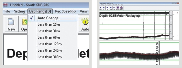
28Sb.jpg

Auto change of depth range                                                          Real-time display


PowerNav (for navigation purpose)

·New software kernel, faster processing and more stable

·Professional Engineering map sheet and data management, wizard-style parameter setting

·High compatibility, flexible to import graphs and data, connectible to all GPS devices and echo sounders

·Modular designed, meets diverse needs of hydrographic engineering projects


SDE28D
  • Max. power consumption [W]
    400
  • Min. external DC power [V]
    9
  • Max. external DC power [V]
    18
  • Min. external AC power [V]
    110
  • Max. external AC power [V]
    260
  • Weight in air [kg]
    7.5
  • Width [m]
    0.14
  • Length [m]
    0.35
  • Height [m]
    0.29
  • Software platform
    Windows XP
  • Min. depth of operation [m]
    0.3
  • Max. depth of operation [m]
    2000
  • Min. frequency [kHz]
    20
  • Max. frequency [kHz]
    200
  • Min. power output [W]
    300
  • Max. power output [W]
    800
  • Min. beam angle [deg]
    7
  • Max. beam angle [deg]
    7
  • Depth resolution [m]
    0.01
  • Max. sounding rate [Hz]
    30
  • Real-time sound velocity and temperature profile inclusion
    Y